
Thinking Out Loud - Circle Towns
Does anyone remember life before digits? This is me picking my way cross country back when the windshield and a map were the primary nav aids. Another ancient re-written Grassroots tale.

The tiny cockpit tilted and I briefly held the bank — my eyes intent on catching the sparse collection of buildings and house trailers as they flowed from under the lower left aileron. The parallel railroad tracks emerged and one diverged 45 degrees to the right. One track cut the cluster of houses nearly in half, while the other remained on its western outskirts. I smiled. Positive identification! I knew exactly where I was. Equally as important: I now knew Crowman, Georgia, existed.
On the map Crowman (not its real name) was one of those tiny empty circles with a name that in-obtrusively litter every sectional map aviators used to use when finding their way cross country. They still litter all modern sectionals, but the circles are so close to being invisible that you wouldn’t know they existed unless you were looking for them. Crowman’s circle was wedged between two black lines with hash marks. However, from the chilled confines of my little airplane, it was another one of those blessed sights that exactly matched the two-dimensional symbol on the map at the tip of my heavily gloved left thumb.
The landscape flowed out from beneath the wing while my thumb worked its way down the severely folded and creased map. I was seeking out points of positive identification to verify that yes, the compass heading in the little window is right and, yes, the wind triangles on the E6B calculator hadn’t lied.
At 140 mph, the town flashed past in seconds and twisting my head as best I could, but it still disappeared from my peripheral vision in less time than I had to digest the view.
I like to examine the small towns represented by empty circles as long as possible because I try to imagine life as defined by that circle. Glancing around in the clear, cool 50-mile visibility air not one clump of civilization-induced haze indicated a town of any size was within a neighborly distance — a fact confirmed by the sectional. On the map Crowman only had other small circles spread out in a random pattern around it for company. I couldn’t help but wonder about the original settlers of these specific towns in those specific locations. Why here? Maybe it was water or the fortuitous crossing of a river and a major trading route. Or maybe that was just where some long-ago ancester ran out of energy in the push west out of the colonies. Or where some band of disheartened ex‑Confederate soldiers decided they‘d try to scratch out a postwar living.
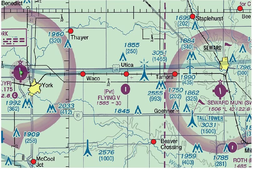
A Study in Circle Towns: 31 miles separate Seward, Nebraska, where I was born and raised, and York where I took my first three flying lessons (I finished in Lincoln). Seward didn’t have an airport. Interstate 80 slashes through the area, completely replacing Rt.34, the long time asphalt artery of the area. I-80 doesn’t even recognize the circle towns (red circles) on either side exist. Its purpose is to get people from there to someplace else as quickly as possible. Seward was a resounding, affluent town of 3800 people (now twice that) while the little circle towns shown now range from 14 to 1000 residents with 500 being average, Each resident has a life, a purpose in life and a determination to defeat whatever challenges them. And they do so without the rest of the Nation even knowing they exist.
As with all circle towns, the single road passing through Crosman is small. My quick perusal couldn’t identify a gas station or weight scale that might cause a trucker or tourist to lift a foot off the gas pedal long enough to find out what Crowman was all about. The big cars of the city folks didn‘t even slacken their pace on the way through. For them, Crowman was nothing more than a mild disturbance in the flat agrarian landscape. It was simply a marker that told them how far they had traveled.
These days most pilots don’t see the circle towns any differently than do the 18-wheelers hellbent for a distant truck terminal. GPS and Foreflight have seen to that. Very few pilots have a thumb creeping up a sectional chart on a mile-by-mile basis, letting them know precisely where they are within a few miles. In fact, the vast majority of pilots may not even know circle towns exist on maps because the circles are so small they are no long of use to mark an aviator’s position and progress. Even as seen from the third dimension, the lives of circle towns are slipping into anonymity, as they continue their slide into near extinction.
Watching Crowman come out from under that aileron, I felt the personal inner calm that comes with positive position identification. It was so good to know exactly where I was. I wished I could tell the people below that for a split-second. their existence had not only been duly noted by someone outside their own inner circle, but their existence had meant something important and, in more difficult navigational situations, could have even been the difference between life and death.
Although certainly not a life or death matter, knowing exactly where I was was important for peace of mind. On that particular flight, any solitarycircle town contributed mightily to that peace of mind. I was ferrying a friend’s Pitts from NJ to FL and had immediately found the VOR was totally inop and the compass was somewhere between 35 and 25 degrees out. However, once I figured out the ideal heading it was a perfectly usable instrument, as long as I didn‘t want to go east or west.
It’s in situations like this that circle towns become some of our very best friends. Position is so critical that I was picking my way from a bend in the river, to a particular crossroad, to the big tree in the backyard of the corner house. This is when the tiny circle towns earn their keep. Many times they are in the middle of a totally featureless nowhere that flows to the horizon and the big questions include “Is that the little road shown on the map, or is that a cow path? And how do I know exactly where I am on it?” Then a circle town shows up, telling me exactly where my traveling thumb should be on the map. This not only marks my progress but establishes my position so I know exactly where every airport in the area can be found, should I need one. They also give me the approximate heading required to get to point “B“ having left point “A“ far behind. Who needs GPS?
Those tiny little settlements, really nothing more than random collections of lives, definitely don’t qualify for their own irregularly-shaped block of official yellow on an FAA sectional chart which would signify them as a real town. They have effectively been erased from maps which show the “big picture,” and even the average world atlas will blip over them completely. However, to the people who are born and raised in that location, the feeling of the streets and of the fields that flow right up to the city limits are central to their lives. Central to their ways of thinking. What appears as an empty circle on a map, or is seen from the air as a few pitiful houses huddled together, is actually the continuing saga of people’s lives. They are part of the continuum that guarantees the past has a bridge, however tenuous, to the future.
Far too often, these small towns are on their last legs and the collective face of the population is creased and weathered. The young have fled, leaving the old and/or stubborn behind to keep the ghosts from invading their town and turning it into some-thing that no longer exists. To those survivors, the town is primarily a recollection of times past, since they can see little or no future. Their present is often a faltering step from one day to the next, as they look around and see the rest of the world going about their business without them. Often, they feel disconnected as if the cities and the names funneled in by satellite dish belong to another country. Another time. At the same time, for some, that separation is what they treasure most.
It often frustrates me as I watch a circle town slipping past my wing tip that there‘s no way I can convey to them that a certain small segment of the rest of the world, the old school aviators, know they do indeed exist. I wish there was a way they could know that everytime they glance up at a ragwing biplane or Cub there is another face up there looking back at them. The face is carefully scrutinizing their main street, the geography of their road and rail system. I wish I could tell them that, although the recognition is transitory, they and their small town do mean something very important to a person they will never meet and may never see again.
At airplane speeds, circle towns are left behind quickly. Fortunately, there‘s always another just ahead.
You took me back to 1972 when I flew my G3 cup to Oshkosh. I was building cross-country time in those days and did almost all of it the way you fly. It truly taught me how to look outside and fly a straight line.
When flying my Cub through the north woods of Michigan's Upper Peninsula, where even the roads are few and far between, a sectional, compass and watch gave precious little confidence as to your whereabouts. Behold that little sawmill with the creek running north and south....Hah, 10 more minutes and doubt starts creeping back into your psyche again. Rinse, repeat.
mb